Digital and integrated Asset Management Software
Forget Excel spreadsheets, obsolete data, and disconnected accounting records. With Geomap AMS, you can digitize the entire asset lifecycle, from recognition to accounting valuation.
End-to-End Solution for Facility and Asset Management
Cloud SaaS, accessible anywhere
The power of AI integrated into the software
Designed to save time, increase control and reduce errors
A single platform Accessible Scalable Traceable
From survey to budget: everything under control
Geomap AMS offers you the tools to manage your assets in an integrated, precise and compliant way.
Complete and customizable fixed asset sheets
Each asset is managed through a detailed asset record, customizable to your needs. You can enter technical, accounting, and logistical data, classifications, preservation status, cost center, and much more. Everything is editable and trackable over time.
Photos, location, documents and QR/RFID labels
Associate photos, physical location in the building or on the map, and technical and administrative documents with each asset. Physically label each asset with a QR code or RFID to ensure rapid and unique identification at any time.
Photos, location, documents and QR/RFID labels
Associate photos, physical location in the building or on the map, and technical and administrative documents with each asset.
Physically label each asset with a QR code or RFID to ensure rapid and unique identification at any time.
Mobile app for census and field updates
With our tablet app, you can record and update assets directly in the field, even offline.
Operators are guided step-by-step through information collection and labeling. Everything is synchronized in real time with the central system.
View in cartography and planimetry
Geomap AMS allows you to locate each asset directly on a map or floor plan.
With a simple click, you can access complete information about an asset, view it in its physical context, and monitor its condition.
Off-site and multi-location asset management
Not just headquarters: you can also manage and locate assets located in branch offices, remote warehouses, or external environments. The system enables precise georeferencing on an urban or regional scale, useful for public administrations, multi-site companies, or logistics networks.
Bidirectional query between data and space
You can search for an asset from the database and instantly see its location on the map, or explore a floor plan and discover which assets are located there.
This type of two-way navigation improves operations and enables spatial analysis of assets.
Integrated management with the accounting system
Geomap AMS can communicate with your company accounting system to align actual field data with asset records.
This ensures consistency between physical assets and book value, improving transparency and reducing discrepancies.
Guided entries and exits
Easily record the inflow and outflow of assets from your assets with guided procedures.
The system assists you in completing the legally required documents, differentiating flows based on the cause of disposal (scrapping, sale, donation, loss, etc.).
Guided entries and exits
Easily record the inflow and outflow of assets from your assets with guided procedures.
The system assists you in completing the legally required documents, differentiating flows based on the cause of disposal (scrapping, sale, donation, loss, etc.).
Always up-to-date reporting and asset registers
Automatically generate fixed asset registers and control reports: balance sheet, transaction history, allocations, residual value, accounting variances.
All documents can be exported to PDF or Excel, ready for audits, reviewers, or administrative management.
Rated excellent by those who use it every day
With Geomap at your side, you manage the future of your real estate assets
Services and Support: The Geomap Method
From the first meeting to Go Live: we’ll guide you step by step towards operational efficiency.
T3 - RELEASE OF REGISTERS AND DOCUMENTATION
Get all your logs and reports up to date and compliant.
We deliver the final report, ready for reviewers, auditors, administrative management, or certification bodies.
T4 - GO LIVE OF THE GEOMAP AMS SYSTEM
We activate the platform and configure it with your real data.
Geomap AMS launches with all the information already integrated. We train staff and quickly make the system operational.
T5 - CONSULTING AND PROCESS UPDATING
We help you keep your inventory alive and up-to-date.
We support your organization in defining operational flows, internal responsibilities, update policies, and periodic asset monitoring.
GEOMAP AMS MOBILE WEB APP
Manage your assets directly from the field
With the Geomap AMS App you can survey, update, and track assets in real time, efficiently and precisely, wherever you are.
Mobile, guided and simplified census
Smart labeling with QR code or RFID
Dashboard and real-time remote control
Cards, documents and maps always available
The Benefits for Your Team
Faster and less stressful census
All data at your fingertips, even in the field
Less paper, less confusion, more efficiency
Immediate traceability with QR code or RFID
Frequently Asked Questions about Geomap AMS
Can I use Geomap AMS even if I don't have an updated inventory?
Yes. Geomap AMS is designed specifically to help you get started even in a disorganized or incomplete situation.
Our team helps you with field surveys, asset labeling, and the creation of asset records directly in the system.
Does the software connect to my management or accounting system?
Yes. Geomap AMS can be integrated with your ERP or accounting system via API or custom procedures.
This way, actual field data can be synchronized with accounting records, reducing variances and double entries.
Does the system also support the disposal of assets?
Absolutely. The divestment form guides the user step-by-step through regulatory compliance, with pre-defined documents and complete traceability of the asset's exit from the estate.
How many locations or users can I manage at the same time?
Geomap AMS is scalable: you can manage a single location or hundreds of locations, with dozens of users.
Each user can have customized roles and permissions. The system is multi-company, multi-client, and multi-site.
How long does it take to get up and running?
It depends on the size of the assets and the initial state of the data.
Our phased methodology guarantees fast and sustainable results.
Is this software also suitable for Public Administration?
Yes. Geomap AMS is already used by public bodies, schools, municipalities, healthcare providers, and universities.
It supports transparency, reporting, and audit requirements of the Court of Auditors.
We are also ISO 9001:2015 certified for census and technical registry services.
Next step
Book a free consultation with one of our experts. In 30 minutes, you’ll discover how you can simplify your asset management with Geomap AMS.
For over 25 years, we have supported .


Our Services to Support Your Growth

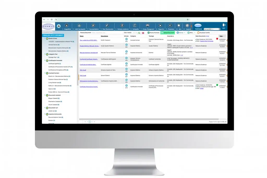
Asset inventory and accounting reconciliation
Give coherence and value to your business assets
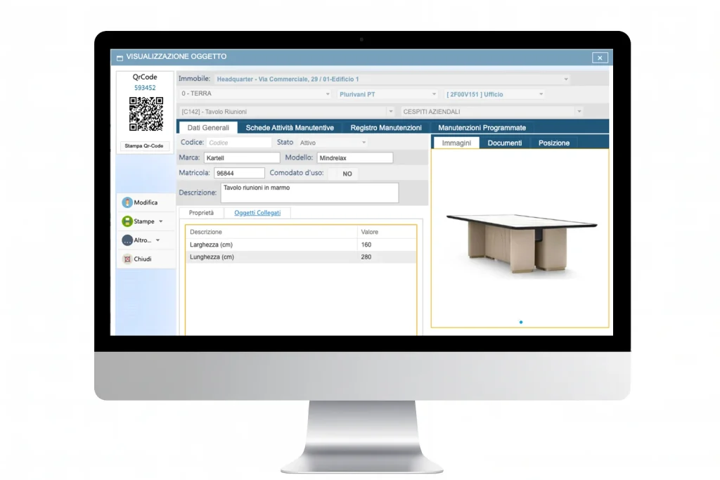
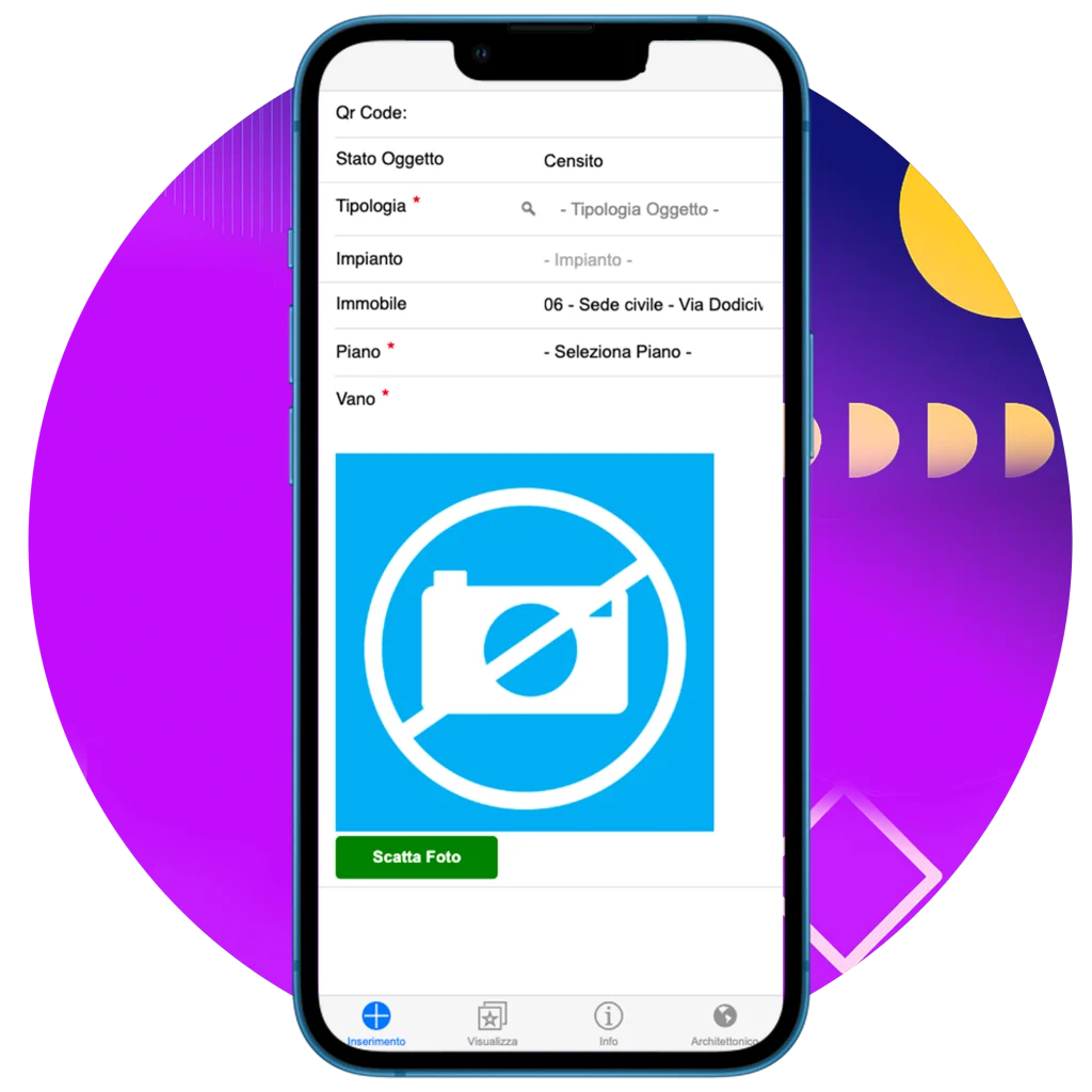
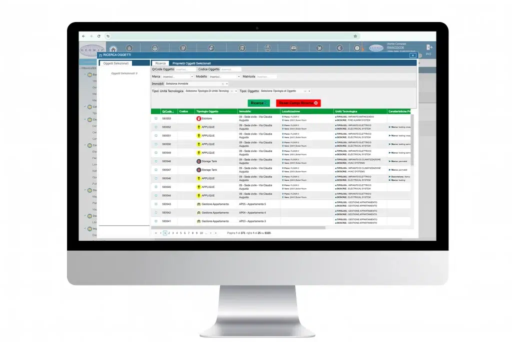
Plant census
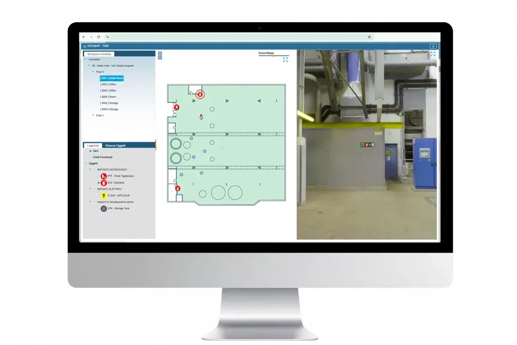
Transform any building, facility or urban area into a navigable and measurable digital model

3D Laser Scanner Survey
Create a digital twin of every real estate asset to make more efficient decisions.
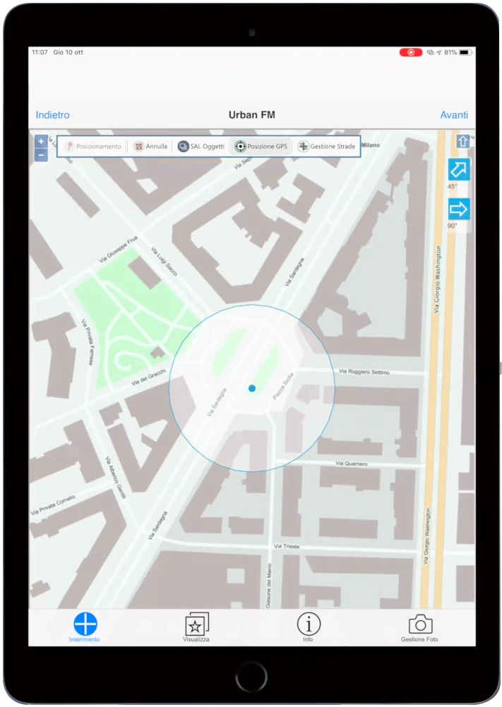
Drone Surveying
Map large areas in high definition and with maximum precision

Scan to BIM
We convert laser surveys into BIM models to design and manage all key information

Scan to CAD
We generate detailed 2D CAD drawings to support design and documentation
